By Ryan Adamson, AccuWeather meteorologist
Published Jul. 8, 2022 6:28 AM MDT | Updated Jul. 11, 2022 11:03 AM MDT
An active start to the North American monsoon has helped to keep temperatures relatively in check in the Southwest recently, but AccuWeather forecasters say that the chance of thunderstorms will decrease in the coming days, allowing temperatures to swell across the region.
Much of the monsoon’s moisture has been focused over Colorado, New Mexico and southeastern Utah as of late. Farther to the west, many locations have received very little, if any, rain. When the ground is dry, the sun’s energy is not needed to evaporate moisture. Instead, the ground is heated quickly which results in higher temperatures.
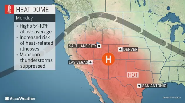
As a ‘heat dome‘ intensifies over the West this week, temperatures will be on the rise. Underneath a heat dome, sinking air causes temperatures to climb, and precipitation and cloud cover tend to be limited.
One example of a city that will continue to be under the dome of heat is Las Vegas. The last time Las Vegas had measurable rain was on March 28 when 0.1 of an inch of rain fell. Sin City is actually in the midst of its second-driest start to the year on record, according to the National Weather Service. This extended period of dryness will allow for efficient heating by the sun, and the mercury will rise to a scorching 112 degrees Fahrenheit on Monday, just shy of record territory. Similar values are likely on Tuesday and Wednesday.
People planning to visit outdoor destinations, such as Zion National Park and Arches National Park in Utah, should avoid hiking in the afternoon when temperatures are near their peak.
Phoenix received 0.31 of an inch of rain in late June thanks to monsoonal thunderstorms. However, no measurable rain has fallen since, and the ground is fairly dry. Temperatures in excess of 110 degrees began on Friday and stand a good chance of reaching that mark each day this week. The highest predicted temperature is 114 degrees on Monday, which would be 7 degrees above average for the date. However, the temperature may be few degrees lower in some Phoenix neighborhoods thanks to the city’s Cool Pavement Program, which aims to reduce the intensity of the urban heat island effect.
As high as these temperatures are expected to be, daily record highs are unlikely to be broken.
“Record heat may be hard to come by for many locations because this is already a hot time of year,” explained AccuWeather Meteorologist La Troy Thornton.
The heat will peak a bit later in Salt Lake City, as the heat dome builds northward throughout this week. On Sunday, Salt Lake City reached 100 degrees for the fourth time this month and third straight day.
Since normals and records are not as high in Salt Lake City as they are in the Desert Southwest, this may be an exception to records being out of reach. On Saturday, Salt Lake City surpassed the old daily record high of 102 F set in 1994.
With moisture suppressed, the monsoonal thunderstorms will be spotty outside of New Mexico. However, given the lack of moisture, any thunderstorms that do develop may produce more lightning than rain. These are called dry thunderstorms as most or all of the rain falling from the clouds evaporates before making it to the ground, while lightning from the storm could spark fires in the parched landscape.
The greater focus of any thunderstorms should be on the edge of the heat dome.
“The monsoon’s moisture will shift west and fuel spotty thunderstorms across the mountains of Nevada and California by the middle of the week,” said AccuWeather Senior Meteorologist Mike LeSeney.
Farther east into Texas, the heat will also remain firmly in place. Nearly everywhere in the state is likely to reach the century mark on Monday. Some of the most intense heat is forecast for Austin, Texas, where a high of 106 F or greater is forecast each day through Wednesday.
Toward the southeast in Houston, which often sees slightly lower temperatures due to an influence from the Gulf of Mexico, a high of 101 is projected for Monday. The intense heat has sparked concerns from some regarding the power supply in some areas, which will face a sharp spike in energy usage during the hottest hours of the day. Late on Sunday, ERCOT, Texas’s largest power grid operator, requested that customers conserve power during the afternoon on Monday.
It may take until the upcoming weekend for temperatures to lower somewhat as the heat dome finally begins to weaken and shift eastward.
SPREAD THE NEWS
COMMENT, Like, Follow & SHARE @I70Scout
CURRENT EDITION
WEATHER & TRAFFIC PUZZLES RECENT NEWS ADVERTISE WITH US

Leave a Reply