By , AccuWeather Meteorologis
An atmospheric river of moisture stretching from the tropical Pacific into the Pacific Northwest will continue to dump heavy rain and mountain snow into this weekend.
As the Pineapple Express brought a steady rain to the Pacific Northwest Thursday, both Seattle and Olympia set daily rainfall records. The cities picked up 1.32 inches and 2.17 inches respectively. As of 8 a.m. PST Friday, Olympia and Shelton, Washington, had picked up more than 4 inches of rain from the storm.
Portions of the Pacific Northwest have been experiencing a moderate drought, so the rain and snow will be beneficial. However, too much of a good thing in such a short amount of time will lead to some problems across the region.
Flood watches extend up and down the Oregon and Washington coasts through Saturday, where persistent moderate to heavy rain was falling. In Bellevue, Washington, police posted a photo of a car that was trapped in floodwaters and urged the public to not attempt driving through deep water.

“Luckily, this driver swam to safety,” the department wrote on Twitter, reminding motorists to “Please be careful!”
At higher elevations, heavy snow is causing a whole different set of dangers. Across the Cascades and Olympic Mountains, winter storm and avalanche warnings are in place because several feet of snow is expected in addition to the snow already on the ground.

Olympic National Park in Washington has seen an explosion of snowfall over a 12-day period through mid-December. A webcam posted high up on Hurricane Ridge in the Olympic Mountains showed no snow-cover whatsoever as recently as Dec. 8. By Friday, Dec. 20, immense snowfall had almost entirely obscured the view from the webcam at Hurricane Ridge.
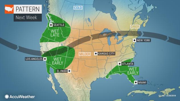
On Friday, the atmospheric firehose of rain and snow will continue to fire at the Pacific Northwest coastline, generally from Portland, Oregon, northward into Washington.
The steadiest and heaviest rain is likely to fall across the Olympic Peninsula, areas surrounding the Puget Sound and along upsloping areas of the Cascades. Through the entire rainfall event spanning from Thursday through Saturday, some areas could reach an AccuWeather Local StormMax™ of 10 inches.

As moisture streams into the Cascades, heavy snow is expected to pile up above 4,000 feet. By the time the event wraps up this weekend, the high country could be buried under 5 or more feet of fresh snow.
So much snow in such a short amount of time has prompted avalanche warnings across the Cascades. Skiers looking to head out and hit the fresh powder late this week and into this weekend will need to take necessary precautions to avoid falling victim to these dangerous phenomena.
While the heaviest rain will largely stay north of Oregon on Friday, southerly winds of 25-45 mph with higher gusts along the coast will prove to be difficult for those traveling along U.S. Route 101 along the Oregon coast.
Rain and snow coverage will expand southward in coverage Saturday, bringing wet weather to places like Eugene and Medford, Oregon, and into Northern California as well.

“As the jet stream shifts farther south on Saturday, the bull’s-eye for flooding rain will transfer from the Washington coast southward to portions of western Oregon and Northern California.” AccuWeather Meteorologist Mary Gilbert stated.
Travel along Interstate 5 from Seattle to Northern California will likely have weather-related issues courtesy of the persistent wet weather on Saturday.
Along with disruptions in travel across the Pacific Northwest, there is increasing concern for area rivers overflowing their banks.

“Heavy rain falling over a relatively short period will likely cause at least minor flooding issues in the region.” Gilbert said.
“In situations such as this, where snow levels rise to the intermediate elevations of the Cascades and Olympics, rapidly melting snow with heavy rain can lead to rapid rises along the short-run rivers in the region,” Sosnowski added.
Remember, if you happen to see flowing water over roadways, turn around, don’t drown.
By Sunday, the storm system bringing the plume of moisture into the Pacific Northwest is expected to track into the California coastline. As it does so, the widespread rainfall will come to an end.

As the storm system comes ashore, it will draw down colder air, lowering the snow levels across the Cascades. While only occasional snow showers will remain over the mountains by Sunday, some of those can occur under 3,000 feet in elevation. Snoqualmie and Steven’s Pass, Washington, receiving rain into Saturday could turn slippery by Sunday.
With the exception of the occasional shower along the Pacific Northwest coast early next week, conditions look to settle down in the days leading up to Christmas.
SPREAD THE NEWS
COMMENT, Like, Follow & SHARE @I70Scout
CURRENT EDITION
WEATHER & TRAFFIC PUZZLES RECENT NEWS ADVERTISE WITH US

Leave a Reply