As cold air and surging warmth collide, a whopper of a storm system will unleash a variety of travel-disrupting weather impacts such as heavy snow, severe weather and winds up to 90 mph across the nation’s midsection.
AccuWeather Global Weather Center – October 20, 2022 – A substantial flip-flop in the weather pattern will allow a major storm to unfold smack dab in the middle of the United States this weekend and persist into early next week. The storm’s variety of adverse weather conditions could lead to a multitude of travel problems and will pose some risk to lives and property from the Rockies to the Great Plains, AccuWeather meteorologists warn.
Everything from strong, dry winds to severe thunderstorms capable of producing heavy rain, hail and even tornadoes will erupt in the southeastern zone of the developing storm where warmer air will be in place. However, on the storm’s northwestern flank, the combination of plunging temperatures, heavy snow and gusty winds may produce localized blizzard conditions.

A strong warming trend will accelerate well ahead of the developing storm over the Plains and Midwest into this weekend and in the wake of abnormally cold weather that made it feel like winter this week. A temperature rise of 50-70 degrees Fahrenheit will occur over a matter of a few days.

Strong winds to roar from Arizona to Minnesota
“The warmup will be accompanied by gusty south-to-southwest winds that will raise the risk of wildfire ignition and rapid spread,” AccuWeather Senior Meteorologist Brett Anderson said. “The winds can also kick up dust from the deserts and blow it hundreds of miles to the Great Plains.”
The strongest winds will develop as colder air from the Northwest begins to catch up with the warmth from the Southwest states to portions of the central and southern Plains by Sunday and Sunday night.
“In the zone from northeastern New Mexico and northwestern Texas to southeastern Colorado and central Kansas, frequent gusts will range from 60-80 mph with an AccuWeather Local StormMax™ of 90 mph,” Anderson said. At this intensity, trucks can be flipped over, property damage can occur and power lines may come down.
Violent thunderstorms to strike at night
The same clash of warm and cold air combined with surging moisture from the Gulf of Mexico and a strong jet stream overhead will trigger severe thunderstorms from portions of the central Plains to the Upper Midwest late Sunday afternoon to Sunday night.
“The thunderstorm threat includes the full spectrum of severe weather ranging from localized flash flooding and large hail to the likelihood of powerful wind gusts and the potential for a few tornadoes,” AccuWeather Chief Meteorologist Jonathan Porter said.
High winds will be the most common threat from the storms, and gusts could approach 100 mph in some cases. Forecasters say there is a heightened risk with this incoming storm system because the majority of the storms may occur toward sunset and after dark Sunday night when they may be difficult to spot in advance.
The zone AccuWeather meteorologists have outlined as the greatest risk for severe weather extends from northeastern Kansas and northern Missouri to southern Minnesota.

Winds, snow could create blizzard conditions
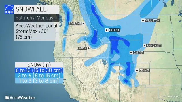
As colder air packed with moisture from the Pacific rolls southeastward over the Rockies and helps to fuel the storm over the Plains, freezing levels will lower over the mountainous terrain to the point where snow works its way down from the ridges and peaks to intermediate levels from Saturday night to Monday.
Enough cold air and moisture are likely to be present to bring a general 6-12 inches of snow with local amounts to 30 inches in portions of the Wasatch in Utah, the Rockies in Colorado, the Tetons in Wyoming and the Sawtooth Range in Idaho.


Leave a Reply