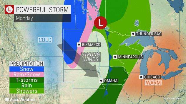
“As a strong cold front moves through, the jet stream will quickly sink out of Canada and well south of the region, allowing polar air to spill southward and eastward,” AccuWeather Senior Meteorologist Mike LeSeney explained.
AccuWeather Global Weather Center – October 24, 2022 –A potent storm has started a big change for many in the western United States, bringing cold air and the first accumulating snow of the season for many spots.
In recent days, much of the Northwest and northern Rockies have felt more like late summer rather than autumn. This past Thursday, temperatures reached the 70s Fahrenheit in Spokane, Washington and soared to around 80 degrees in cities like Bend, Oregon, and Reno, Nevada, temperatures that are more than 15 degrees above normal for October.
Following the warmth, chill has swept the area.
The arrival of this storm sent temperatures plunging for the start of the past weekend across the Northwest. High temperatures were in the 40s and 50s through Sunday. Conditions deteriorated Saturday night and, by Sunday morning, snow stretched from Canada to Utah and Colorado.

“The storm is forecast to strengthen early week, allowing for snow to fill in and for strong winds to develop,” said AccuWeather Meteorologist Brandon Buckingham.
As colder air packed with this moisture from the Pacific rolls southeastward over the Rockies and helps to fuel the storm over the Plains, freezing levels will lower over the mountainous terrain. This drop in temperature will allow rain to change to snow over the ridges and peaks and intermediate elevations through Monday.

As of Sunday evening, the highest snow total came from the mountains around Alta, Utah, which recorded 20 inches. Several other mountain locations reported over a foot of snow including Brighton, Utah, and Big Sky, Montana.
The stormy weather will come with some notable hazards, especially for travel. Motorists should expect delays along with the possibility of road closures, including portions of interstates 70, 80, 90 and 94 and possibly along a stretch of Canada’s Highway 1 in the provinces of Manitoba and Saskatchewan due to the snow.
This could be especially true across the lower elevations of the northern Plains. While the amount of snow may be limited, a narrow area of heavy snow is likely. Blizzard conditions may occur in a part of this region where high winds combine with snow to reduce the visibility to 1/4 mile or less.


Leave a Reply