fbpx

Tag: Travel Delay

  • Massive storm looming over Pacific to wreak havoc up and down West Coast

    Massive storm looming over Pacific to wreak havoc up and down West Coast

    By Kyle Elliott, AccuWeather meteorologist

    After one storm system walloped Southern California and Arizona with heavy rain and high-country snow this week, a much larger storm is set to slam Central and Northern California with a wide array of impacts from Friday into Saturday.

    Although the center of the storm system will move ashore in Oregon later Saturday into Saturday night, the worst of the impacts will occur farther to the south.

    Heavy rain and gusty winds will target coastal areas from San Francisco northward into southern Oregon spanning Friday into Saturday, as well as the Central Valley’s I-5 corridor from Sacramento to Redding.


    The foothills of the Sierra Nevada will also be hit hard with flooding downpours during this time.

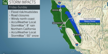
    A general 1-2 inches of rain is forecast in the lowest elevations of the I-5 corridor and San Francisco Bay area, while 2-4 inches is more likely in coastal areas of Northern California.

    It is in the coastal ranges and foothills of the Sierra, however, that rainfall totals of 3-6 inches will occur. An AccuWeather Local StormMax™ of 8 inches is anticipated in these regions.

    Because California is no longer suffering from drought and has actually been abnormally wet over the past one to two weeks, the heavy rainfall will significantly heighten the risk for flooding and mudslides, especially in burn-scar areas from this year’s wildfires.

    Significant travel delays and road closures are also likely, especially in areas where stream and river flooding occurs or where mudslides cover roadways or cause them to collapse.

    “In addition to the extreme amounts of rain, falling snow levels will allow snow to accumulate across the higher terrain of the Sierra Nevada, which will act as a boon for local ski resorts,” AccuWeather Meteorologist Brandon Buckingham said.

    Snow levels will likely fall below 5,000 feet in the Cascades and northern Rockies on Saturday and as low as 5,500 feet in the Sierra Nevada.

    Spanning Friday to Saturday night, AccuWeather meteorologists expect at least 1-2 feet of snow to bury Donner Pass along I-80 in Northern California with 2-4 feet in the highest elevations.

    An AccuWeather Local StormMax™ of 50 inches of snow is expected in the highest terrain of Northern California.

    Motorists traveling through the Sierra Nevada should be aware of chain requirements and be prepared with an emergency survival kit in case their vehicle breaks down or stalls.

    “While major snowfall accumulations farther north in the Washington and Oregon cascades are not expected from this storm system, any snow will be beneficial since these areas are suffering from abnormally dry conditions,” Buckingham added.

    In addition to the copious amounts of rain and snow slated for the end of the week and start of the weekend, gusty winds will buffet the northern half of California and southern part of Oregon.

    Wind gusts of 40-50 mph will threaten to cause sporadic power outages and may help weaken loose topsoil inundated by too much water, further enhancing the risk of mudslides. Blizzard conditions may occur at times in the Sierra Nevada.

    Drier conditions should gradually return from Sunday into Monday as the storm system pushes into the Rockies and Plains.

    Looking ahead into next week, storm-weary residents of California should finally catch a break from the onslaught as the storm track shifts farther north into the Pacific Northwest.


    SPREAD THE NEWS

    COMMENT, Like, Follow & SHARE @I70Scout

    CURRENT EDITION

    WEATHER & TRAFFIC    PUZZLES    RECENT NEWS    ADVERTISE WITH US
     

  • Powerful storm to slam West Coast with feet of snow, flooding rain late this week

    Powerful storm to slam West Coast with feet of snow, flooding rain late this week

    After one storm system wallops Southern California and Arizona with heavy rain and high-country snow through Wednesday night, a much larger storm is set to slam Central and Northern California with a wide array of impacts from Friday into Saturday.

    Although the center of the storm system will move ashore in Oregon later Saturday into Saturday night, the worst of the impacts will occur farther to the south.

    Heavy rain and gusty winds will target coastal areas from San Francisco northward into southern Oregon spanning Friday into Saturday, as well as the Central Valley’s I-5 corridor from Sacramento to Redding.

    The foothills of the Sierra Nevada will also be hit hard with flooding downpours during this time.

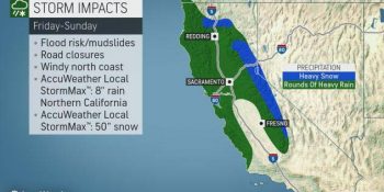
    A general 1-2 inches of rain is forecast in the lowest elevations of the I-5 corridor and San Francisco Bay area, while 2-4 inches is more likely in coastal areas of Northern California.

    It is in the coastal ranges and foothills of the Sierra, however, that rainfall totals of 3-6 inches will occur. An AccuWeather Local StormMax™ of 8 inches is anticipated in these regions.

    Because California is no longer suffering from drought and has actually been abnormally wet over the past one to two weeks, the heavy rainfall will significantly heighten the risk for flooding and mudslides, especially in burn-scar areas from this year’s wildfires.

    Significant travel delays and road closures are also likely, especially in areas where stream and river flooding occurs or where mudslides cover roadways or cause them to collapse.

    “In addition to the extreme amounts of rain, falling snow levels will allow snow to accumulate across the higher terrain of the Sierra Nevada, which will act as a boon for local ski resorts,” AccuWeather Meteorologist Brandon Buckingham said.

    Snow levels will likely fall below 5,000 feet in the Cascades and northern Rockies on Saturday and as low as 5,500 feet in the Sierra Nevada.

    Spanning Friday to Saturday night, AccuWeather meteorologists expect at least 1-2 feet of snow to bury Donner Pass along I-80 in Northern California with 2-4 feet in the highest elevations.

    An AccuWeather Local StormMax™ of 50 inches of snow is expected in the highest terrain of Northern California.

    Motorists traveling through the Sierra Nevada should be aware of chain requirements and be prepared with an emergency survival kit in case their vehicle breaks down or stalls.

    “While major snowfall accumulations farther north in the Washington and Oregon cascades are not expected from this storm system, any snow will be beneficial since these areas are suffering from abnormally dry conditions,” Buckingham added.

    In addition to the copious amounts of rain and snow slated for the end of the week and start of the weekend, gusty winds will buffet the northern half of California and southern part of Oregon.

    Wind gusts of 40-50 mph will threaten to cause sporadic power outages and may help weaken loose topsoil inundated by too much water, further enhancing the risk of mudslides. Blizzard conditions may occur at times in the Sierra Nevada.

    Drier conditions should gradually return from Sunday into Monday as the storm system pushes into the Rockies and Plains.

    Looking ahead into next week, storm-weary residents of California should finally catch a break from the onslaught as the storm track shifts farther north into the Pacific Northwest.


    SPREAD THE NEWS

    COMMENT, Like, Follow & SHARE @I70Scout

    CURRENT EDITION

    WEATHER & TRAFFIC    PUZZLES    RECENT NEWS    ADVERTISE WITH US