fbpx

Tag: Rockies

  • LARRY WALKER BECOMES FIRST ROCKIES PLAYER ELECTED TO HALL OF FAME

    LARRY WALKER BECOMES FIRST ROCKIES PLAYER ELECTED TO HALL OF FAME

    Walker received 76.6% of votes in 10th and final year on ballot

     DENVER — It was announced this evening that Larry Walker has been elected to the National Baseball Hall of Fame after receiving 76.6% of the vote in his 10th and final year on the ballot. The announcement was made by National Baseball Hall of Fame and Museum President Tim Mead live on MLB Network.

     Walker becomes the first player in Rockies history to be elected to the Hall of Fame. He is the seventh player in the modern voting era (since 1966) to be elected in his final year of eligibility and the third player over the past four years to be elected in his 10th and final year on the ballot (also Tim Raines in 2017, Edgar Martinez in 2019).

     Eligible candidates must be named on 75% of the ballots from voting members of the Baseball Writers Association of America in order to be elected. Walker received 54.6% of the vote in 2019, marking an improvement of 22.0% in his final year on the ballot. That is the largest year-to-year percentage increase to earn election to the Hall of Fame in the modern voting era.

     The Class of 2020 also includes shortstop Derek Jeter, catcher Ted Simmons and executive Marvin Miller. They will be inducted on Sunday, July 26 at the National Baseball Hall of Fame and Museum in Cooperstown, N.Y.

     Born on December 1, 1966 in Maple Ridge, B.C., Canada, Larry Walker played parts of 17 Major League seasons from 1989-2005, including parts of 10 seasons with the Rockies from 1995-2004. In his career, he batted .313 (2,160-for-6,907) with 1,355 runs, 471 doubles, 62 triples, 383 home runs, 1,311 RBI, 230 stolen bases and 913 walks. As a Rockie, Walker batted .334 (1,361-for-4,076) with 297 doubles, 44 triples, 258 home runs, 848 RBI, 126 stolen bases and 584 walks. He ranks first in Rockies history in batting average, on-base percentage (.426) and slugging percentage (.618). He ranks second, behind Todd Helton, in runs, hits, doubles, home runs and RBI.

     In 1997, Walker became the only player in Rockies history to win the National League Most Valuable Player Award after leading the Major Leagues with a .720 slugging percentage, a 1.172 OPS and 409 total bases. His 49 home runs that season led the National League, and remain tied with Todd Helton’s 2001 total for the most single-season home runs in Rockies franchise history.

     He was named a National League All-Star five times (1992, 1997-99, 2001) and earned seven Gold Gloves in right field (1992-93, 1997-99, 2001-02) in addition to his three Silver Sluggers (1992, 1997, 1999). Additionally, he was a three-time National League Batting Champion (1998-99, 2001) as a member of the Rockies.

     Prior to signing with Colorado before the 1995 season, Walker played parts of six seasons with the Montreal Expos (1989-94) and batted .281 (666-for-2,366) with 368 runs, 147 doubles, 16 triples, 99 home runs, 384 RBI across 674 games. He concluded his Major League career with parts of two seasons for the St. Louis Cardinals (2004-05), where he batted .286 (133-for-465) with 95 runs, 27 doubles, two triples, 26 home runs, 79 RBI, six stolen bases and 65 walks across 144 games.

     “I know I speak for the whole Rocky Mountain Region in congratulating Larry for his election into the Hall of Fame,” said Rockies Owner/Chairman & CEO Dick Monfort. “Larry blessed our region for parts of 10 seasons and we feel extremely fortunate to be a part of his incredible career. Congrats, Larry.”


    SPREAD THE NEWS

    COMMENT, Like, Follow & SHARE @I70Scout

    CURRENT EDITION

    WEATHER & TRAFFIC    PUZZLES    RECENT NEWS    ADVERTISE WITH US


  • Massive storm looming over Pacific to wreak havoc up and down West Coast

    Massive storm looming over Pacific to wreak havoc up and down West Coast

    By Kyle Elliott, AccuWeather meteorologist

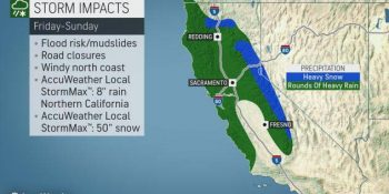
    After one storm system walloped Southern California and Arizona with heavy rain and high-country snow this week, a much larger storm is set to slam Central and Northern California with a wide array of impacts from Friday into Saturday.

    Although the center of the storm system will move ashore in Oregon later Saturday into Saturday night, the worst of the impacts will occur farther to the south.

    Heavy rain and gusty winds will target coastal areas from San Francisco northward into southern Oregon spanning Friday into Saturday, as well as the Central Valley’s I-5 corridor from Sacramento to Redding.


    The foothills of the Sierra Nevada will also be hit hard with flooding downpours during this time.

    A general 1-2 inches of rain is forecast in the lowest elevations of the I-5 corridor and San Francisco Bay area, while 2-4 inches is more likely in coastal areas of Northern California.

    It is in the coastal ranges and foothills of the Sierra, however, that rainfall totals of 3-6 inches will occur. An AccuWeather Local StormMax™ of 8 inches is anticipated in these regions.

    Because California is no longer suffering from drought and has actually been abnormally wet over the past one to two weeks, the heavy rainfall will significantly heighten the risk for flooding and mudslides, especially in burn-scar areas from this year’s wildfires.

    Significant travel delays and road closures are also likely, especially in areas where stream and river flooding occurs or where mudslides cover roadways or cause them to collapse.

    “In addition to the extreme amounts of rain, falling snow levels will allow snow to accumulate across the higher terrain of the Sierra Nevada, which will act as a boon for local ski resorts,” AccuWeather Meteorologist Brandon Buckingham said.

    Snow levels will likely fall below 5,000 feet in the Cascades and northern Rockies on Saturday and as low as 5,500 feet in the Sierra Nevada.

    Spanning Friday to Saturday night, AccuWeather meteorologists expect at least 1-2 feet of snow to bury Donner Pass along I-80 in Northern California with 2-4 feet in the highest elevations.

    An AccuWeather Local StormMax™ of 50 inches of snow is expected in the highest terrain of Northern California.

    Motorists traveling through the Sierra Nevada should be aware of chain requirements and be prepared with an emergency survival kit in case their vehicle breaks down or stalls.

    “While major snowfall accumulations farther north in the Washington and Oregon cascades are not expected from this storm system, any snow will be beneficial since these areas are suffering from abnormally dry conditions,” Buckingham added.

    In addition to the copious amounts of rain and snow slated for the end of the week and start of the weekend, gusty winds will buffet the northern half of California and southern part of Oregon.

    Wind gusts of 40-50 mph will threaten to cause sporadic power outages and may help weaken loose topsoil inundated by too much water, further enhancing the risk of mudslides. Blizzard conditions may occur at times in the Sierra Nevada.

    Drier conditions should gradually return from Sunday into Monday as the storm system pushes into the Rockies and Plains.

    Looking ahead into next week, storm-weary residents of California should finally catch a break from the onslaught as the storm track shifts farther north into the Pacific Northwest.


    SPREAD THE NEWS

    COMMENT, Like, Follow & SHARE @I70Scout

    CURRENT EDITION

    WEATHER & TRAFFIC    PUZZLES    RECENT NEWS    ADVERTISE WITH US