fbpx

Category: Weather & Traffic

  • Dust in the wind: Enormous cloud stretches clear across Atlantic Ocean

    Dust in the wind: Enormous cloud stretches clear across Atlantic Ocean

    The monstrous size of the Saharan dust cloud trekking from Africa to the Gulf Coast has made meteorologists’ heads turn and has stirred up conversation on how this year’s health impacts from the plume could be more concerning than others in the past.

    Over the past week, this vast expanse of dust, known as the Saharan Air Layer (SAL), has been called the “Godzilla dust cloud,” as well as the “most significant event in the past 50 years,” by some experts, according to The Associated Press. By Wednesday afternoon, the leading edge of the dust plume had invaded the airspace over the Gulf of Mexico, satellite imagery showed.

    Satellites show two areas of concentration with the dust as the plume stretches from continent to continent. The first concentration now clouds the Caribbean, more than a week after a thunderstorm complex that had moved across western Africa kicked up the dust.

    “Dust has been flowing off the coast of Africa for several weeks now, which is not uncommon,” AccuWeather Senior Meteorologist and lead hurricane expert Dan Kottlowski said. “But the extent and concentration of dust currently in the Caribbean is by far very impressive.”

    “The depth of the dust, as measured in various places, suggests that this is one of the most concentrated areas of dust we have seen in the past several years,” Kottlowski said, although he acknowledged that records of dust concentrations are not well established.

    The bulk of the first concentration of dust reached Puerto Rico and the U.S. Virgin Islands on Monday, not just clouding the sky but turning it a milky white.

    Visibility at the airport on St. Croix in the U.S. Virgin Islands dropped to 3 miles and was limited to 5 miles in San Juan, Puerto Rico. In past years, the SAL plumes have allowed 10 or more miles of visibility at the surface, according to Gabriel Lorejo, a meteorologist at the National Weather Service in San Juan.

    “We have many models that indicate the highest dust concentration is from around 5,000 feet all the way down to the surface. It’s pretty extreme,” Lorejo told The Washington Post.

    The aerosol optical depth, a measurement commonly used to estimate the amount of particulate matter in the air, was as high as 2 on Monday, a level not seen there during June in 15 years of record-keeping, Dr. Olga Mayo, an atmospheric chemist at the University of Puerto Rico, told The Washington Post.

    “This is probably the worst air quality caused by Saharan dust in recent memory,” Kottlowski said. “Dust particles are like any other pollution such as smoke. Low-level dust is usually a very short-term issue such as when one experiences dust in a dust storm. But this is different because it’s not local dust, it’s dust that originated at least 4,000 miles away and has been falling out to the ground since then.”

    Indeed, a look at the air quality in Negril, Jamaica, on the island’s west coast, provided by Plume Labs showed that conditions were “very unhealthy” as the Saharan dust enveloped the atmosphere. AccuWeather and Plume Labs have a partnership that allows users to monitor the realtime air quality in a given location from the AccuWeather website or mobile app.

    Air quality in Puerto Rico was fair as of Wednesday morning, according to the data from Plume Labs. But the SAL has coated some cars left outside in a fine layer of dust early in the week. Ada Monzon, chief broadcast meteorologist at WAPA-TV in Puerto Rico, has been following the dust plume as it’s moved over the Atlantic toward the Caribbean. She posted photos on Twitter sent to her by viewers showing how outdoor surfaces had been covered in a thin film of dust.

    The reddish color of the dust indicates the iron contained in it. When this iron is deposited over a large body of water, it can promote the growth of algae blooms, according to Kottlowski.

    Meteorologists at NOAA on Tuesday posted animated satellite imagery on Twitter showing the huge dust plume moving across the Atlantic over a five-day period. The images, seen below, were captured by the GOES-16 satellite.

    “Extensive dust extends west to the eastern Yucatan Peninsula and Belize,” Kottlowski said. “However, an upper-level disturbance that will cause heavy and perhaps flooding rainfall over East Texas the next two to three days will halt the westward progression of dust for a time.”

    The system is forecast to lift out to the northeast between Thursday and Friday, opening the door for more concentrated dust to fill the skies over East Texas Friday or Friday night into Saturday. Like it has in the Caribbean, the dust is expected to bring reduced visibility and poor air quality from eastern Texas to Louisiana.

    “Those sensitive to poor air quality should pay close attention to local officials advising the public on air quality,” Kottlowski said. “Eventually, the dust will flow up into other Gulf Coast states around the western then northern periphery of an area of high pressure nosing into the northern Gulf of Mexico.”

    Residents in the southern areas of Mississippi, Alabama, Georgia and parts of Florida are likely to see hazy skies and deal with a drop in air quality this weekend into early next week.

    As the dust moves westward, some of the more concentrated dust will precipitate out or spread out, becoming less concentrated, according to Kottlowski. With the diminishing of dust levels, the impacts most likely won’t be as dramatic as what has been seen in Puerto Rico.

    “However, it will still be unusual, and people will notice some haze and a milky-looking sky with little or no blue sky visible for most of Friday, Saturday and Sunday over East Texas,” Kottlowski said.

    Dust particles hanging in the air have been known to cause hazy, red sunrises and sunsets. Volcanic ash and smoke from wildfires have had similar effects. However, if there are too many particles in the air, they could instead dull the sunrises and sunsets as they have in the Caribbean lately.

    The concentration of dust this year will most likely continue to cause poor air quality in the Gulf Coast, coming at a time with high concerns over COVID-19, which affects the respiratory system.

    “Air quality could also drop to moderate to unhealthy this weekend over South and East Texas due to the dust,” Kottlowski said. “So, people with respiratory issues should not spend any long periods of time outdoors. Some people with severe respiratory conditions may just want to stay indoors.”

    The hospitals in Texas are currently at a breaking point. In Houston, the Texas Children’s Hospital has been admitting adult patients to help ease the strain on other facilities. As of Tuesday, the state had 118,093 confirmed cases, placing it as the fifth state with the most cases, according to data from Johns Hopkins University. The state’s death toll as of Wednesday stood at 2,236.


    SPREAD THE NEWS

    COMMENT, Like, Follow & SHARE @I70Scout

    CURRENT EDITION

    WEATHER & TRAFFIC    PUZZLES    RECENT NEWS    ADVERTISE WITH US
     

  • Memorial Day DUI enforcement period kicks off Friday 323 motorists cited during same enforcement period last year

    STATEWIDE — As Colorado slowly loosens stay-at-home restrictions, the Colorado Department of Transportation (CDOT) and Colorado State Patrol (CSP) want to remind Coloradans to drive sober as Memorial Day weekend approaches. The Heat Is On high-visibility enforcement period kicks off on Friday, May 22, and ends on Tuesday, May 26.

     Seventy-five law enforcement agencies will participate in the heightened enforcement campaign with increased patrols across the state. Those enjoying Memorial Day festivities away from home are encouraged to plan for a sober ride if they intend to consume alcohol or other impairing substances.

     “Safety on Colorado’s roadways isn’t just CDOT’s goal – it should be a focus for every single person on the road,” said Shoshana Lew, Executive Director of CDOT. “Your safety and the safety of those around you are at stake when you drive impaired. All of us want to make it home safely, so don’t jeopardize that by driving impaired.”

     During the 2019 Memorial Day weekend DUI enforcement period, law enforcement agencies arrested 323 impaired motorists. Last May alone, there were 16 impairment-related fatalities on Colorado’s roads.

     The legal blood-alcohol content (BAC) limit in Colorado is 0.05 percent for driving while ability impaired (DWAI) and 0.08 percent for driving under the influence (DUI). First-time DUI offenders can be punished with up to one year in jail, license suspension and thousands of dollars in fines.

     “Memorial Day is a day to remember military personnel who died while serving the country.  It also tends to be associated with increased travel and alcohol consumption due to the long weekend.  We want Coloradans to be safe, maintain social distancing practices, and make the decision to never drive impaired,” said Colonel Matthew Packard, Chief of the Colorado State Patrol.  “Plan ahead for a sober ride if you are celebrating away from home.” 

     The Heat Is On will be back with its Summer Blitz DUI enforcement from June 12-22. During last year’s summer enforcement, 585 citations were given to impaired drivers with the highest arrests seen from the Colorado Springs Police Department (52), the Denver Police Department (33) and the El Paso County Sherriff’s Office (32). The summer months and holiday weekends traditionally show an increase in DUI crashes and arrests. Law enforcement is always on the lookout for impaired drivers and working to keep Colorado roads safe.

     CDOT’s The Heat Is On DUI-prevention campaign is a key component of CDOT’s Whole System — Whole Safety initiative to reduce traffic injuries and deaths.

     COVID19

    Safe transportation infrastructure is essential for emergency first responders and freight drivers as Colorado navigates the COVID-19 pandemic. With that in mind, road maintenance and construction continues on CDOT projects with social distancing and other health safety measures to reduce COVID-19 exposure on the worksite. The Colorado Department of Public Health and Environment announced guidelines for construction activities. The public is urged to join the campaign for #DoingMyPartCO by practicing social distancing, wearing face masks, staying at home when possible, and avoiding nonessential travel. With fewer vehicles on the roads, CDOT crews will be able to work more efficiently and safely.

     ABOUT THE HEAT IS ON

    The CDOT Highway Safety Office provides funding to Colorado law enforcement for impaired driving enforcement, education and awareness campaigns. The Heat Is On campaign runs throughout the year, with 16 specific high-visibility impaired driving enforcement periods centered on national holidays and large public events. Enforcement periods can include sobriety checkpoints, saturation patrols and additional law enforcement on duty dedicated to impaired driving enforcement. Find more details about the campaign, including impaired driving enforcement plans, arrest totals and safety tips at HeatIsOnColorado.com.

     WHOLE SYSTEM. WHOLE SAFETY.  

    In early 2019, CDOT announced its Whole System — Whole Safety initiative to heighten safety awareness. This initiative takes a systematic, statewide approach to safety combining the benefits of CDOT’s programs that address driving behaviors, our built environment and the organization’s operations. The goal is to improve the safety of Colorado’s transportation network by reducing the rate and severity of crashes and improving the safety of all transportation modes. The program has one simple mission—to get everyone home safely.

    ABOUT CDOT

    CDOT has approximately 3,000 employees located at its Denver headquarters and in regional offices throughout Colorado, and manages more than 23,000 lane miles of highway and 3,429 bridges. CDOT also manages grant partnerships with a range of other agencies, including metropolitan planning organizations, local governments and airports. It also administers Bustang, the state-owned and operated interregional express service. Gov. Polis has charged CDOT to further build on the state’s intermodal mobility options.


    SPREAD THE NEWS

    COMMENT, Like, Follow & SHARE @I70Scout

    CURRENT EDITION

    WEATHER & TRAFFIC    PUZZLES    RECENT NEWS    ADVERTISE WITH US


  • Overnight closures of westbound I-70 ramp to westbound I-270

    As part of the Colorado Department of Transportation’s Central 70 Project, motorists should expect two overnight closures of the westbound Interstate 70 ramp to westbound I-270 so crews can remove the existing layer of asphalt and pave the ramp.

    TRAFFIC IMPACTS:

    • Westbound I-70 ramp to westbound I-270 full closure –  9 p.m., Saturday, May 2 to 8 a.m., Sunday, May 3, and 9 p.m., Monday, May 4 to 5:30 a.m., Tuesday, May 5.
      • Motorists should use westbound I-70 to northbound I-25 as an alternate route. 


    This work is weather dependent and subject to change. 

    COVID-19

    Safe transportation infrastructure is essential for emergency first responders and freight drivers as Colorado navigates the COVID-19 pandemic. With that in mind, road maintenance and construction continues on CDOT projects with social distancing and other health safety measures to reduce COVID-19 exposure on the worksite. The Colorado Department of Public Health and Environment announced guidelines for construction activities. The public is urged to join the campaign for #DoingMyPartCO by practicing social distancing, wearing face masks, staying at home when possible, and avoiding nonessential travel. With fewer vehicles on the roads, CDOT crews will be able to work more efficiently and safely. 

     Whole System.Whole Safety 

    Earlier this year, CDOT announced its Whole System — Whole Safety initiative to heighten safety awareness. This initiative takes a systematic, statewide approach to safety combining the benefits of CDOT’s programs that address driving behaviors, our built environment and the organization’s operations. The goal is to improve the safety of Colorado’s transportation network by reducing the rate and severity of crashes and improving the safety of all transportation modes. The program has one simple mission—to get everyone home safely.

    About the Central 70 Project

    The Central 70 Project will reconstruct a 10-mile stretch of I-70, add one new Express Lane in each direction, remove the aging 56-year-old viaduct and lower the interstate between Brighton and Colorado boulevards. More information on the Project, including a list of the Project’s community commitments, are available at central70.codot.gov.


    Stay Informed

    • Text Alerts – Text Central70 to 77948
    • Email Updates – Sign up for Project Updates at c70.codot.gov 
    • Website – c70.codot.gov – Traffic Impacts page 
    • Watch progress on the webcam 


  • Drive-up Testing Lab Will be Postponed  to Tomorrow Due to Weather-Related Safety Concerns / El laboratorio móvil no ofrecerá servicio debido al estado del tiempo

    Drive-up Testing Lab Will be Postponed  to Tomorrow Due to Weather-Related Safety Concerns / El laboratorio móvil no ofrecerá servicio debido al estado del tiempo

    People Who Need COVID-19 Tests Can Obtain Them Through Private Providers

    DENVER, March 13, 2020: Due to weather-related concerns, CDPHaE will postpone the drive-up testing site in Lowry to tomorrow, Saturday, March 14, weather permitting. Current weather conditions put both people being tested and laboratory staff at risk. Cold temperatures can reduce the effectiveness of personal protective equipment (PPE) that protect testing staff from being exposed to the virus and passing it on to others. 

    Testing will take place tomorrow from noon-2 p.m. The testing center will be able to serve the first 100-150 people in line. 

    Because Colorado now has capacity for private labs to conduct testing, CDPHE encourages anyone who is symptomatic or who believes they may have been exposed to COVID-19 to call or email their physician first for guidance, obtain a doctor’s order for testing, and request information about private providers where you can get tested. Always call first before reporting to a health care facility for testing.    Providers such as UCHealth, Kaiser Permanente, Children’s Colorado, and Stride Community Health Center have testing capacity.

    Any medical provider with a relationship with LabCorp or Quest Diagnostics can test, but be sure to contact your provider ahead of time because many providers have centralized sites for testing due to safety precautions.    People should remember: • If you have a medical emergency, call 911 – do not report to a testing site, as they are not emergency care facilities. If you have severe respiratory symptoms, especially shortness of breath or difficulty breathing, tell the 911 dispatcher about your symptoms. Do not wait for a COVID-19 test to call 911.

    • If you are ill or suspect that you were exposed, but are not able to be immediately tested, please stay home, self-isolate, and contact your physician. 
    • While waiting for their test results, individuals should stay at home. Those who receive positive test results may be issued isolation orders.
    • The Colorado Division of Insurance is directing carriers to ensure that coverage is provided for COVID-19 testing, in-network provider office visits, in-network urgent care center visits, and an emergency room visit when a covered person is seeking testing for COVID-19 without the requirement that consumers pay co-pays, deductibles or co-insurance. Carriers must also cover testing by an out-of-network provider, if they cannot conduct the testing.  The division is working on formalizing these directives. The mobile testing center in Lowry has served more than 650 people since it opened on Wednesday. 

    Continue to stay up to date by visiting colorado.gov/cdphe/2019-novel-coronavirus.   


    Las personas que necesiten exámenes de COVID-19 pueden obtenerlas a través de proveedores privados

    DENVER, Marzo 13, 2020: El Departamento de Salud y Medio Ambiente de Colorado (CDPHE), no abrirá el laboratorio móvil en Lowry hoy viernes 13 de marzo, debido a las condiciones del tiempo, que arriesga a las personas que son examinadas y también al personal del laboratorio. Las bajas temperaturas pueden afectar el equipo protector del personal del laboratorio que los cubre para no exponerse al virus y contagiar a otras personas.  

    Las pruebas tomarán lugar mañana de 12:00 pm – 2:00 pm.  Se podrán atender a las primeras 100-150 personas en la fila. 

    Debido a que Colorado tiene la capacidad de que los laboratorios privados hagan las pruebas, CDPHE indica que cualquier persona que presente síntomas o que crea haber estado expuesta a COVID-19, debe llamar o mandar un correo electrónico a su médico para que reciba instrucciones, obtenga una orden del doctor y pida información sobre proveedores privados donde se puedan hacer la prueba.  Siempre llame antes al proveedor de salud médica para hacer la prueba. 

    Proveedores como  UCHealth, Kaiser Permanente, Children’s Colorado, and Stride Community Health Center have tienen capacidad para hacer las pruebas.

    Cualquier proveedor médico con una relación con LabCorp o Quest Diagnostics puede hacer la prueba,pero asegúrese de contactar a su proveedor médico con anticipación porque muchos proveedores tienen lugares centralizados para colectar pruebas por precaución.

    Se debe recordar:

    • Si tiene una emergencia, llame al 911 – no lo reporte a un lugar donde hacen las pruebas, debido a que estos lugares no son lugares de emergencias.  Si tiene síntomas respiratorios severos, especialmente dificultad para respirar, llame al 911 y dígale al operador sus síntomas.  No espere a hacerse una prueba de COVID-19 para llamar al 911. 
    • Si esta enfermo o piensa que ha sido expuesto, pero no pueden hacerse la prueba inmediatamente, por favor quédese en casa, aislado y contacte a su médico.  
    • Mientras esperan sus resultados, las personas deben quedarse en casa.  Los que resulten positivos, debe mantenerse aislados.
    • La División de Seguros de Colorado indicó a los proveedores que para asegurar la cobertura por la prueba de COVID-19, visitas a proveedores dentro de la red, cuidado urgente y visitas a emergencias cuando una persona tiene cobertura y busca pruebas del COVID-19 sin el requerimiento que los usuarios cubran co-pagos, deducibles o co-seguro.  Los proveedores deben cubrir la prueba para los que están fuera de la red, si no pueden hacer la prueba.  La División esta trabajando para formalizar estas directrices.

    El laboratorio móvil en Lowry le ha dado servicio a 650 personas desde que abrió el miércoles.  CDPHE avisará sobre la reapertura del laboratorio móvil en Lowry. 

    Actualizaciones  colorado.gov/cdphe/2019-novel-coronavirus.


    SPREAD THE NEWS

    COMMENT, Like, Follow & SHARE @I70Scout

    CURRENT EDITION

    WEATHER & TRAFFIC    PUZZLES    RECENT NEWS    ADVERTISE WITH US


  • CANCELED • Mile House • Open House

    CANCELED • Mile House • Open House

    CANCELED: Due to adverse snow conditions, Saturday’s Open House is canceled.

    This Saturday, see what Valentine’s Day looked like in the 1800s with vintage valentines, refreshments and family-friendly crafts, including a make-your-own valentine you can take home. Join us for this special Open House on Saturday, Feb. 8 at the 17 Mile House at 8181 South Parker Road in Centennial.

    SPREAD THE NEWS

    COMMENT, Like, Follow & SHARE @I70Scout

    CURRENT EDITION

    WEATHER & TRAFFIC    PUZZLES    RECENT NEWS    ADVERTISE WITH US


  • It’s here: AccuWeather’s 2020 US spring forecast

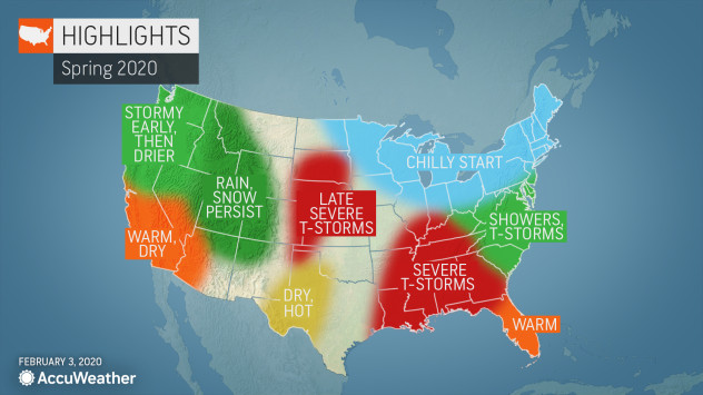
    The wait is over. For those hoping to thaw out from winter’s chill, AccuWeather’s annual spring forecast is here. Though Punxsutawney Phil recently declared the end of winter, AccuWeather meteorologists largely disagree and are calling for the current season to drag on across much of the United States, possibly even beyond the official beginning of spring.

    Mild air will be slow to arrive in the Northeast, Great Lakes and Ohio Valley this year, as the chance for snow lingers into mid-spring. Meanwhile, the Southeast will brace for a wet and stormy couple of months.

    The season will be split in the West as some areas will experience a prolonged winter season and others may seemingly skip the season altogether and jump ahead to summer.

    Take a look at the complete region-by-region breakdown below:

    Northeast, Great Lakes, Ohio Valley

    Spring will seemingly get off to a late start this year as winter weather stretches into late March for the Northeast, Great Lakes and Ohio Valley.

    “It looks to me like cold and snow combined could linger this year before we see a break by mid-spring,” AccuWeather Expert Long-Range Meteorologist Paul Pastelok said.

    The delayed warmth will be good news for ski resorts, particularly in Vermont, New Hampshire and Maine, where snow cover will persist the longest.

    The I-95 corridor from Washington, D.C., to Boston is more likely to have rain mixed with snow, similar to what the region has experienced during much of the winter.

    For most of the regions, temperatures will start to climb in April. However, a few cold spells are possible in the Upper Midwest and Northeast in May, preventing a rapid change to summer.

    Toward the end of spring, severe weather events will become more frequent in the Northeast and mid-Atlantic. Pittsburgh, Cleveland and Philadelphia may be in the line of fire, Pastelok said.

    Meanwhile, rain may lead to planting delays in the eastern Ohio Valley, Tennessee Valley and Southeast.

    CLICK HERE FOR THE FREE ACCUWEATHER APP

    Southeast, Tennessee Valley, Gulf States

    A wet weather pattern is in store for the Southeast this spring, with most of the rain falling in the first half of the season. 

    “We’ve already seen a pretty active southern jet stream with a lot of storms. I think that continues into the spring season and that’s going to lead to some flooding,” Pastelok said.

    Severe storms will frequent the Gulf states and the Tennessee Valley, particularly during late March and April. Warm Gulf waters paired with an active storm track could lead to a couple of big events for the regions, including cities like Atlanta, Birmingham, Alabama, and even Jackson, Mississippi.

    As May rolls around, a quieter weather pattern will replace the wet and stormy conditions.

    SPREAD THE NEWS

    COMMENT, Like, Follow & SHARE @I70Scout

    CURRENT EDITION

    WEATHER & TRAFFIC    PUZZLES    RECENT NEWS    ADVERTISE WITH US


  • With the Quadrantid meteor shower peaking this weekend, Jackson Lake State Park has the dark skies for a dazzling display

    With the Quadrantid meteor shower peaking this weekend, Jackson Lake State Park has the dark skies for a dazzling display

    The International Meteor Organization (IMO) is projecting that the Quadrantid meteor shower will peak around 1 a.m. Saturday. AccuWeather predicts that most of Colorado, including the eastern plains, will have good viewing conditions for the shower. And Jackson Lake State Park offers up the dark skies to showcase it all.

    By Amy Brandenburg, Park Ranger at Jackson Lake State Park

    ORCHARD, Colo. – Ralph Waldo Emerson probably said it best, “The sky is the ultimate art gallery just above us.” 

    Venturing from Denver and the metro area, the sky is clouded with an orange haze and inorganic glow. However, once on the eastern plains of Colorado, a traveler can pull the car over on a country road, get out, look up and be astounded at the beautiful sights that encompass the sky above him. This is one of the very unique things about living outside of the city, which most people forget about, because their eyes are looking down at their phones. 

    Morgan County has exceptionally dark skies once you journey away from our still quiet towns onto a county road. We should consider ourselves lucky to still be one of the few places our children can look up and see the big dipper, or even the Milky Way on a clear night.

    Jackson Lake State Park is taking these dark skies one step further. The park was awarded two separate grants – $3,500 from the Colorado Parks Foundation and $20,000 from the Director’s Innovation Grant – to fund a “Dark Skies Initiative.” 

    This project consists of eliminating and changing out lights inside and outside all buildings on the park to be “dark skies friendly.” This means that lights are fully shielded, point straight down and have a color temperature less than 3000 kelvins. Bathroom buildings will also have sensors inside, so that lights are not staying on all evening. 

    Aside from causing less light pollution for night sky viewing, research has shown that this specific type of lighting is less harmful to wildlife that migrate in the night. Some birds even rely on stars for their migration path. Studies have also found that increased lighting has little to no effect on decreasing crime rates. Additionally, having dark areas is also known to help people reset their circadian rhythm, which is the biological clock that relies on the daily cycles of lightness and darkness; more on these topics to follow in upcoming articles. 

    Jackson Lake is not alone in this lighting feat; they are also working with Morgan County Rural Electric Association to remove the large light poles at the park to increase opportunities to see those beautiful stars above. 

    Since the lighting will be so minimal at Jackson Lake State Park, it will become an even more significant place to visit during unique celestial and lunar events. One of Jackson Lake’s frequent amateur astronomers stated, “I drive out twice a month to get away from the city’s light dome, so I can enjoy the night sky in such a way that is impossible to do in Denver. You can actually see the Milky Way.”

    Photo by Nora Logue

    The grants also affords the park the opportunity to acquire a new telescope to use while hosting educational and interpretive programs for the public. Guests can expect several experts in the field to share their knowledge, as well, at certain times of the year.

    Furthermore, in the evenings, rangers will be educating campers to “light their site, not the night.” Many new RVs and motor homes have large amounts of exterior lights, which are generally unnecessary, use excess energy and can cause neighboring campers to have a limited view of the night sky. 

    By making these changes, Jackson Lake State Park is hoping to gain the accreditation of an “International Dark Skies Place” from the IDA (International Dark Skies Association). If the title is granted, Jackson Lake State Park will be the only state park in Colorado, and the only accredited place in Colorado east of I-25 to be certified. 

    It is a very exciting endeavor for Jackson Lake State Park, an endeavor they hope will create a new unique reason to visit Morgan County.


    SPREAD THE NEWS

    COMMENT, Like, Follow & SHARE @I70Scout

    CURRENT EDITION

    WEATHER & TRAFFIC    PUZZLES    RECENT NEWS    ADVERTISE WITH US


  • Christmas storm to drop rain, snow across Southern California

    Christmas storm to drop rain, snow across Southern California

    By Courtney Spamer, AccuWeather meteorologist – Updated Dec. 24, 2019 8:50 AM

    Yet another storm will target Southern California through Christmas, allowing wet weather to linger into the busiest travel day left in 2019.

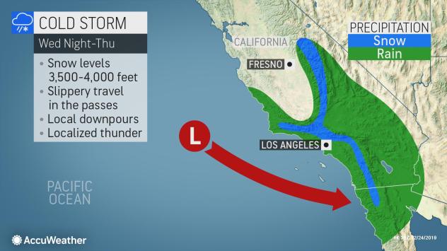
    The storm will spread rain across the San Francisco Bay Area to the Los Angeles Basin from Tuesday night and into Wednesday before it strengthens Christmas night.

    While periods of rain occur at the coast and in the valleys, a more wintry feel will occur late on Christmas Day for some of the higher elevations.

    “Snow levels will drop as low as 3,500 to 4,000 feet Wednesday and Thursday across Southern California, allowing any rain to change over to snow in the Grapevine,” said AccuWeather Senior Meteorologist Brett Anderson.

    The highest elevations may see as much as 12 to 18 inches of snow.

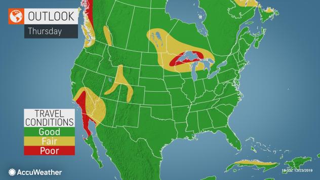
    Some of the major passes could have enough snow to cause travel issues, including Tejon Pass along Interstate 5 and Laguna Summit along I-8.

    Those planning to travel through these areas should be prepared for delays and have fully winterized their vehicles.

    Snow will not be the only precipitation to cause travel troubles through Thursday, as even those at the coast could experience delays.

    “Rainfall amounts of 1-2 inches will be possible through Thursday across the L.A. Basin,” added Anderson. An AccuWeather Local StormMax™️ of 4 inches is possible into Thursday evening.

    This much rain will bring the potential for ponding on the roadways as well as slower travel.

    For Southern California, Thursday is expected to be the busiest travel day following Christmas, according to the American Automobile Association (AAA).

    The wet weather is likely to add to the congestion for motorists throughout the day.

    The storm may also add to some delays for major airport hubs like Los Angeles International Airport and San Diego International Airport both on Christmas Day and the busier travel day of Boxing Day.

    This storm will move through the southern Rockies during the latter half of the week, and eventually into the center of the country for the weekend.

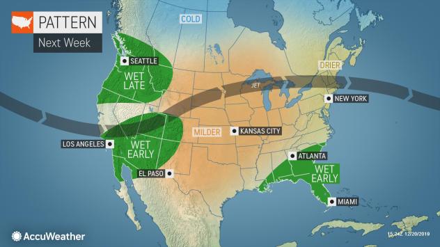
    Meanwhile, California looks to be on the drier side through the end of the year. However, the pattern is setting up in such a manner that at least one more storm could dive across the state before 2020 begins.


    SPREAD THE NEWS

    COMMENT, Like, Follow & SHARE @I70Scout

    CURRENT EDITION

    WEATHER & TRAFFIC    PUZZLES    RECENT NEWS    ADVERTISE WITH US

     

  • Cheaper Gas Coming Soon

    Cheaper Gas Coming Soon

    Colorado pump prices to dip by at least a quarter.

    DENVER (Dec. 19, 2019) – Good news, Colorado: AAA forecasts that Centennial State motorists will enjoy some of the country’s most significant savings on gas heading into the new year, with pump prices expected to plummet by as much as a quarter in the coming weeks. The reason? Increasing gasoline stocks coupled with an anticipated seasonal demand drop will together drive prices down.

    Regional gasoline stocks have averaged 7 million barrels since early October, per data from the Energy Information Administration. Refinery utilization rates, meanwhile, have hovered around 85 percent or higher. Those two factors, combined with the seasonal switch-over to winter-blend gasoline – which is cheaper to produce and sell – are driving down gas prices.

    “Pump prices are finally trending downward in Colorado in what has been an abnormally expensive regional gas market, of late,” said AAA Colorado spokesman Skyler McKinley. “The even better news is that 2019’s prices are down nearly a dime from 2018, thanks in large part to cheaper crude oil prices.”

    On a year-to-date basis, Colorado’s 2019 statewide average for a gallon of regular unleaded is $2.57, down from $2.68 in 2018. Gas prices hit their highest point in June, at $2.87, and their lowest in February, at $2.01. Colorado has enjoyed the cheapest gas prices of any state in AAA’s Rockies analysis region – comprising Idaho, Montana, Utah, Wyoming, and Colorado. 

    Oil Market Dynamics

    Colorado’s anticipated savings may be short-lived.

    While crude oil prices have consistently fallen year-over-year, they may hover consistently above $60 per barrel as the Organization of the Petroleum Exporting Countries and its partners continue to reduce production, lowering global supply.

    Earlier this month, OPEC and other major global producers, including Russia, announced an agreement to cut their total crude production by an additional 500,000 barrels per day beginning on January 1, 2020. This new agreement will likely remain in effect, without amendment, until the next OPEC meeting in Vienna, Austria on March 5. 

    “This reduction in global crude supply will help drain the market, which will likely otherwise be oversupplied during the first half of next year,” McKinley said. “This could lead to more expensive crude oil and gas prices in mid-to-late January as compared to the start of recent years, assuming crude demand remains robust.”

    Colorado Gas By the Numbers

     Durango

    • Current Average: $2.57
    • Yesterday Average: $2.58
    • Week Ago Average: $2.57
    • Month Ago Average: $2.65
    • Year Ago Average: $2.54

    Denver

    • Current Average: $2.68
    • Yesterday Average: $2.69
    • Week Ago Average: $2.72
    • Month Ago Average: $2.74
    • Year Ago Average: $2.29

    Colorado Springs

    • Current Average: $2.70
    • Yesterday Average: $2.70
    • Week Ago Average: $2.75
    • Month Ago Average: $2.75
    • Year Ago Average: $2.34

    Pueblo

    • Current Average: $2.73
    • Yesterday Average: $2.74
    • Week Ago Average: $2.83
    • Month Ago Average: $2.87
    • Year Ago Average: $2.52

    Boulder-Longmont

    • Current Average: $2.73
    • Yesterday Average: $2.73
    • Week Ago Average: $2.76
    • Month Ago Average: $2.75
    • Year Ago Average: $2.30

    Greeley

    • Current Average: $2.74
    • Yesterday Average: $2.75
    • Week Ago Average: $2.78
    • Month Ago Average: $2.79
    • Year Ago Average: $2.37

    Fort Collins-Loveland

    • Current Average: $2.76
    • Yesterday Average: $2.77
    • Week Ago Average: $2.78
    • Month Ago Average: $2.79
    • Year Ago Average: $2.40

    Grand Junction

    • Current Average: $2.80
    • Yesterday Average: $2.81
    • Week Ago Average: $2.86
    • Month Ago Average: $2.89
    • Year Ago Average: $2.57

    Glenwood Springs

    • Current Average: $3.09
    • Yesterday Average: $3.09
    • Week Ago Average: $3.13
    • Month Ago Average: $3.16
    • Year Ago Average: $2.83

    Vail

    • Current Average: $3.19
    • Yesterday Average: $3.20
    • Week Ago Average: $3.24
    • Month Ago Average: $3.29
    • Year Ago Average: $2.84

    Winter Fuel & Driving Tips

    As you hit the road this winter, AAA offers these tips to help conserve fuel and keep motorists safe:


    • As a precaution, keep at least half a tank of fuel in your vehicle at all times. It helps to reduce condensation in the fuel system. It also helps ensure an adequate reserve of fuel to run the engine for heat should your car become disabled in a remote location.
    •  
    • Optimize your daily driving.  Maintain steady speeds. A car uses extra fuel accelerating.  Cruise control may be a fuel saving option for motorists who drive a lot because a steady speed conserves fuel.  This is helpful when driving on level roads.  Cruise control, however, hurts mileage if you drive on hilly terrain.  
    • Minimize last-minute braking. Anticipate traffic conditions. Be alert for slow-downs and red lights and coast up to them, if possible. Drive smoothly, avoiding “jackrabbit starts.” The faster you drive, the more fuel used. Remember, however, that traveling slower than traffic flow can cause a safety hazard.
    •  
    • Don’t haul extra weight in the passenger compartment or trunk.   Reducing extra weight can save up to 2% fuel economy for every 100 lbs. removed depending on the weight of the vehicle. Also lose the roof rack, if not used regularly. Carrying things on a roof rack increases aerodynamic drag and reduces fuel economy – year-round.
    • Look into discounts. For example, AAA members can now save 30 cents per gallon on their first fill up, and 5 cents per gallon on every other fill-up, by signing up for the Fuel Rewards program by December 31, 2019. More information at com/Shell

    • Be sure to pack an emergency roadside kit in your car containing a mobile phone and car charger, first-aid kit, blankets, drinking water and snacks, a flashlight with extra batteries, a basic toolkit, warning flares, an ice scraper, jumper cables and a shovel.


    About AAA Colorado

    More than 695,000 members strong, AAA Colorado is the state’s greatest advocate for the safety and security of all travelers. As North America’s largest motoring and leisure travel organization, AAA provides more than 60 million members with travel, insurance, financial, and automotive-related services — as well as member-exclusive savings. A not-for-profit organization since its founding in 1923, AAA Colorado has been recognized as the number one Colorado company its size for its advocacy, community engagement, and corporate social responsibility efforts – and is a proud member of Points of Light’s “The Civic 50 Colorado,” recognizing the 50 most community-minded companies in the state. For more information, visit AAA.com.


    SPREAD THE NEWS

    COMMENT, Like, Follow & SHARE @I70Scout

    CURRENT EDITION

    WEATHER & TRAFFIC    PUZZLES    RECENT NEWS    ADVERTISE WITH US
     

  • Pineapple Express’ streams into Pacific Northwest with flooding rain and heavy snow.

    Pineapple Express’ streams into Pacific Northwest with flooding rain and heavy snow.

    By Brandon Buckingham, AccuWeather Meteorologis

    An atmospheric river of moisture stretching from the tropical Pacific into the Pacific Northwest will continue to dump heavy rain and mountain snow into this weekend.

    As the Pineapple Express brought a steady rain to the Pacific Northwest Thursday, both Seattle and Olympia set daily rainfall records. The cities picked up 1.32 inches and 2.17 inches respectively. As of 8 a.m. PST Friday, Olympia and Shelton, Washington, had picked up more than 4 inches of rain from the storm.

    Portions of the Pacific Northwest have been experiencing a moderate drought, so the rain and snow will be beneficial. However, too much of a good thing in such a short amount of time will lead to some problems across the region.

    Flood watches extend up and down the Oregon and Washington coasts through Saturday, where persistent moderate to heavy rain was falling. In Bellevue, Washington, police posted a photo of a car that was trapped in floodwaters and urged the public to not attempt driving through deep water.

    A car stranded in floodwaters on a road in Bellevue, Washington. Police said the driver of the vehicle escaped unharmed, but urged the public to not take chances driving through deep water. (Bellevue Police Department).

    “Luckily, this driver swam to safety,” the department wrote on Twitter, reminding motorists to “Please be careful!”

    At higher elevations, heavy snow is causing a whole different set of dangers. Across the Cascades and Olympic Mountains, winter storm and avalanche warnings are in place because several feet of snow is expected in addition to the snow already on the ground.

    Satellite animation on Friday, Dec. 20, 2019, shows a plume of moisture extending from the Pacific Ocean west of Hawaii into the Pacific Northwest. (NOAA / GOES)

    Olympic National Park in Washington has seen an explosion of snowfall over a 12-day period through mid-December. A webcam posted high up on Hurricane Ridge in the Olympic Mountains showed no snow-cover whatsoever as recently as Dec. 8. By Friday, Dec. 20, immense snowfall had almost entirely obscured the view from the webcam at Hurricane Ridge.

    On Friday, the atmospheric firehose of rain and snow will continue to fire at the Pacific Northwest coastline, generally from Portland, Oregon, northward into Washington.

    The steadiest and heaviest rain is likely to fall across the Olympic Peninsula, areas surrounding the Puget Sound and along upsloping areas of the Cascades. Through the entire rainfall event spanning from Thursday through Saturday, some areas could reach an AccuWeather Local StormMax™ of 10 inches.

    “Widespread urban and small stream flooding are a given in a pattern such as this,” according to AccuWeather Senior Meteorologist Alex Sosnowski.

    As moisture streams into the Cascades, heavy snow is expected to pile up above 4,000 feet. By the time the event wraps up this weekend, the high country could be buried under 5 or more feet of fresh snow.

    So much snow in such a short amount of time has prompted avalanche warnings across the Cascades. Skiers looking to head out and hit the fresh powder late this week and into this weekend will need to take necessary precautions to avoid falling victim to these dangerous phenomena.

    While the heaviest rain will largely stay north of Oregon on Friday, southerly winds of 25-45 mph with higher gusts along the coast will prove to be difficult for those traveling along U.S. Route 101 along the Oregon coast.

    Rain and snow coverage will expand southward in coverage Saturday, bringing wet weather to places like Eugene and Medford, Oregon, and into Northern California as well.

    “As the jet stream shifts farther south on Saturday, the bull’s-eye for flooding rain will transfer from the Washington coast southward to portions of western Oregon and Northern California.” AccuWeather Meteorologist Mary Gilbert stated.

    Travel along Interstate 5 from Seattle to Northern California will likely have weather-related issues courtesy of the persistent wet weather on Saturday.

    Along with disruptions in travel across the Pacific Northwest, there is increasing concern for area rivers overflowing their banks.

    This motion graphic shows the increase in snow depth across the Olympic Mountains between Dec. 8 and Dec. 20, 2019. (AccuWeather / NOAA)

    “Heavy rain falling over a relatively short period will likely cause at least minor flooding issues in the region.” Gilbert said.

    “In situations such as this, where snow levels rise to the intermediate elevations of the Cascades and Olympics, rapidly melting snow with heavy rain can lead to rapid rises along the short-run rivers in the region,” Sosnowski added.

    Remember, if you happen to see flowing water over roadways, turn around, don’t drown.

    By Sunday, the storm system bringing the plume of moisture into the Pacific Northwest is expected to track into the California coastline. As it does so, the widespread rainfall will come to an end.

    As the storm system comes ashore, it will draw down colder air, lowering the snow levels across the Cascades. While only occasional snow showers will remain over the mountains by Sunday, some of those can occur under 3,000 feet in elevation. Snoqualmie and Steven’s Pass, Washington, receiving rain into Saturday could turn slippery by Sunday.

    With the exception of the occasional shower along the Pacific Northwest coast early next week, conditions look to settle down in the days leading up to Christmas.


    SPREAD THE NEWS

    COMMENT, Like, Follow & SHARE @I70Scout

    CURRENT EDITION

    WEATHER & TRAFFIC    PUZZLES    RECENT NEWS    ADVERTISE WITH US