fbpx

Category: Weather & Traffic

  • DRIVERS CAUTIONED ABOUT I-70 SUN GLARE

    CLEAR CREEK COUNTY – The Colorado Department of Transportation (CDOT) is reminding drivers who travel Interstate 70 about the yearly sun glare problem in the Floyd Hill area.  

    From early November through early February, the sun’s angle, in combination with the hill and the highway’s configuration, can create a blinding sun glare for drivers as they head eastbound up Floyd Hill (mile 244 to 247 – east of Idaho Springs).  The glare occurs from approximately 7 a.m. until 8:30 a.m. However, it is especially severe between 7:30 a.m. and 8 a.m. 

    CDOT will be providing advance notification of the potential hazard with messages on its electronic sign boards prior to Floyd Hill, alerting motorists of the sun glare and to anticipate slower speeds.

              Other driver recommendations include:

    • Making sure the windshield is clean – inside and out
    • Wearing a good pair of sunglasses to provide shading
    • Expecting traffic slowdowns and adjusting your speed to avoid sudden reactions
    • Letting off the accelerator and slowing down gradually instead of slamming on the brakes, if suddenly blinded by the sun
    • Avoiding eastbound travel on Floyd Hill, if possible, between 7 a.m. and 8:30 a.m.


    CDOT also is reminding motorists of Colorado’s Move-It Law, a joint effort between CDOT and law enforcement agencies to encourage motorists to follow a state law requiring drivers involved in minor accidents on interstates to move their vehicle immediately out of traffic to a safe location.  The insurance industry also encourages compliance with the Move It law, reassuring drivers there will still be a full investigation of the crash to determine fault.

    “Many people are apprehensive about moving their vehicle after an accident, worried they’re jeopardizing their insurance coverage,” says Carole Walker, executive director of the Rocky Mountain Insurance Information Association.  “However, when it comes to safety, the industry fully supports taking actions that reduces potential hazards to drivers, first and foremost.”

    Road conditions can change quickly at this time of year.  Drivers can receive updated road and weather information by calling 511 or by going to www.cotrip.org.  Updates also are available via e-mail or text.  Please visit www.codot.gov and click on the envelope icon in the lower right-hand corner.  The link takes you to a list of items you can subscribe to, including I-70 West, Denver to Glenwood Springs.

  • TRAFFIC ADVISORY ***CORRECTED CONSTRUCTION PERIOD*** Ramp closure on westbound I-70 to southbound I-225

    AURORA – The ramp leading from westbound Interstate 70 to southbound Interstate 225 will be closed from 10:00 p.m. on Friday, September 16, until 5:00 a.m. on Monday, September 19. Closures are necessary so crews can install three 44-foot modular joints that each must be installed in one piece across the width of the bridge.

    Traffic is advised to use alternate routes.

    DETOUR ROUTE

    Westbound traffic from I-70 to I-225 will be routed through the Peoria Street interchange to eastbound I-70 so motorists can merge onto I-225 via that ramp; motorists can expect heavy delays around the detour route. It is recommended that motorists avoid the Peoria Street interchange and use the alternate route of Airport Road to East 6th Avenue.

    Local traffic is advised to avoid the I-70/Peoria Street interchange over the weekend as longer than usual delays can be expected on Peoria Street.

    After the ramp reopens on Monday, September 19, motorists can expect nightly single lane closures for the next three weeks from Sunday through Thursday from 9:00 p.m. to 5:00 a.m. so crews can do an overlay the bridge deck. Drivers should be prepared for lane shifts and a reduced speed limit of 45 mph through the project area. Vehicles wider than 12 feet will be restricted from using the ramp during work hours.

    The project is on schedule and expects to finish in late October. Work hours could be extended or additional weekend closures could be scheduled.

    The prime contractor for the $2 million project is Truesdell Corporation.

  • Ramp closure on westbound I-70 to southbound I-225

    AURORA – The ramp leading from westbound Interstate 70 to southbound Interstate 225 will be closed from 10:00 p.m. on Friday, September 16, until 5:00 a.m. on Monday, September 19. Closures are necessary so crews can install three modular joints, and place Polyester Concrete between joints on the north and south ends of the project.

    A signed detour route will be in place for this closure and is listed below.

    DETOUR ROUTE

    It is recommended that motorists use the alternate route of Airport Road to East 6thAvenue. Westbound traffic from I-70 to I-225 will be routed through the Peoria Street interchange to eastbound I-70 so motorists can merge onto I-225 via that ramp.

    It is recommended that local traffic avoid this area over the weekend as longer than usual delays can be expected on Peoria Street.

    After the ramp reopens on Monday, September 19, motorists can expect single lane, shoulder and ramp closures during the course of the project from Monday through Fridayfrom 7:00 a.m. to 6:00 p.m. Drivers should be prepared for lane shifts and a reduced speed limit of 45 mph through the project area. Vehicles wider than 12 feet will be restricted from using the ramp during work hours.

    The project is on schedule and expects to finish in late October. Work hours could be extended or additional weekend closures could be scheduled.

    The prime contractor for the $2 million project is Truesdell Corporation.

  • Front Range Action Day for Ozone

    Front Range Action Day for Ozone

    The Colorado Department of Public Health and Environment and the Regional Air Quality Council have issued an OZONE ACTION DAY ALERT at 4 p.m. on Tuesday, August 16, 2016 for the Front Range Urban Corridor from El Paso County north to Larimer and Weld counties, including the Denver-Boulder area, Colorado Springs, Fort Collins and Greeley.

    A good deal of sunshine combined with favorable winds will result in ozone concentrations occasionally reaching the Unhealthy for Sensitive Groups category on Tuesday and Wednesday. For full details please refer to the Front Range Air Quality Forecast below.

    This Ozone Action Day Alert will remain in effect until at least 4 p.m. Wednesday, August 17, 2016.

    For statewide conditions, forecasts and advisories, visit:
    http://www.colorado.gov/airquality/colorado_summary.aspx

    The highest Ozone related AQI at 1 o’clock PM Mountain Standard Time on August 16, 2016, is 47 which indicates Good ozone air quality. It was recorded by the HLD ambient ozone monitor.

    The highest Particulate Matter (PM2.5) related AQI at 1 o’clock PM Mountain Standard Time on August 16, 2016, is 56 which indicates Moderate Particulate Matter (PM2.5) air quality. It was recorded by the LNGMambient monitor. Respiratory symptoms possible in unusually sensitive individuals, possible aggravation of heart or lung disease in people with cardiopulmonary disease and older adults. Unusually sensitive people should consider reducing prolonged or heavy exertion.
    Front Range Air Quality Forecast & Colorado Smoke Outlook

    FRONT RANGE AIR QUALITY FORECAST:
    Tuesday, August 16, 2016, 2:20 PM MDT

    Ozone concentrations are expected to be in the Moderate to Unhealthy for Sensitive Groups range on Tuesday and Wednesday. Ozone concentrations in the Unhealthy for Sensitive Groups category are most likely from the southwest suburbs of Denver northward to around Ft. Collins, including the nearby foothills both Tuesday and Wednesday. Active children and adults, and people with lung disease, such as asthma, should reduce prolonged or heavy outdoor exertion from 1 PM until 9 PM on Tuesday andWednesday in those areas.

    Fine Particulate Matter concentrations are expected to be in the Good to Moderate range on Tuesday andWednesday. Moderate concentrations of fine particulate matter will mainly be confined to locations along and near the I-25 corridor from Denver northward to Longmont. Unusually sensitive people should consider reducing prolonged or heavy exertion in those areas on Tuesday and Wednesday.

    Carbon Monoxide concentrations are expected to be in the Good category on Tuesday and Wednesday.

    Nitrogen Dioxide concentrations are expected to be in the Good category on Tuesday and Wednesday.

    Visibility is expected to be Moderate to Poor on Wednesday.

    COLORADO SMOKE OUTLOOK:
    Tuesday, August 16, 2016, 2:30 PM MDT

    Air Quality Health Advisory for Wildfire Smoke

    Issued for Hayden Pass Wildfire in Fremont County, approximately 5 miles southwest of Coaldale.
    Issued at 7:30 AM MDT, Tuesday, August 16, 2016

    Issued by the Colorado Department of Public Health and Environment Affected Area: western parts of Fremont County. Locations include, but are not limited to Cotopaxi, Coaldale, Hillside, Howard and Texas Creek.

    Advisory in Effect: 7:30 AM MDT, Tuesday, August 16, 2016 to 9:00 AM MDT, Wednesday, August 17, 2016

    Public Health Recommendations: If smoke is thick or becomes thick in your neighborhood you may want to remain indoors. This is especially true for those with heart disease, respiratory illnesses, the very young, and the elderly. Consider limiting outdoor activity when moderate to heavy smoke is present. Consider relocating temporarily if smoke is present indoors and is making you ill. If visibility is less than 5 miles in smoke in your neighborhood, smoke has reached levels that are unhealthy.

    Outlook: Smoke concentrations have returned to an unhealthy level in Cotopaxi near the Hayden Pass fire. Similar smoke concentrations are likely in Coaldale. The wind will be variable direction on Tuesday with scattered showers and thunderstorms developing during the afternoon. These showers and thunderstorms could produce gusty, erratic winds and send smoke in any direction. Light winds are expected late Tuesday night and Wednesday morning. This will allow smoke to drain towards the Arkansas River, once again impacting Coaldale and Cotopaxi with periods of moderate to possibly heavy smoke. Lighter smoke will be possible in locations such as Howard, Texas Creek, Hillside and possibly into northern parts of Custer County as far south as Westcliffe.

    SMOKE FROM OTHER WILDFIRES:
    Areas of smoke and haze are possible across large portions of northern Colorado, including the northern half of the Front Range region. This is due to smoke being transported from wildfires in other western states. This smoke will be most noticeable during the morning hours and then will diminish during the afternoon as atmospheric mixing increases.

    The 36,435 acre Beaver Creek Wildfire is located in northwestern Jackson County approximately 24 miles northwest of Walden. The wind at the fire on Tuesday will be variable in direction with showers and thunderstorms possible by the afternoon. These showers and thunderstorms could produce erratic, gusty winds and send smoke in any direction. Light winds are expected at the fire late Tuesday night and drainage flow will likely pool smoke to northern parts of North Park into Wednesday morning. This would mainly include the area to the north of the community of Cowdrey to the Wyoming state line.

    The 621 acre Spring Creek 2 Wildfire is located in Garfield and Mesa Counties approximately 5 miles south of Parachute. Smoke may be visible along that stretch of Interstate 70, but fire activity is decreasing and full containment of the fire is expected in the next 24 hours.

    The 335 acre Happy Hollow Wildfire located in Moffat County approximately 25 miles west of Maybell. The wind at the fire on Tuesday will generally be light and variable in direction. An isolated shower or thunderstorm is possible near the fire Tuesday afternoon. If a thunderstorm develops, it could produce erratic, gusty winds and send smoke in any direction. The wind will calm near the fire late Tuesday night andWednesday morning with smoke likely draining down to the Yampa River.

    The 110 acre Lost Solar Wildfire located near the Rio Blanco/Garfield county line approximately 24 miles southwest of Meeker. The wind at the fire on Tuesday will generally be light and variable in direction. An isolated shower or thunderstorm is possible near the fire Tuesday afternoon. If a thunderstorm develops, it could produce erratic, gusty winds and send smoke in any direction. Light winds will continue at the fire late Tuesday night and Wednesday morning with smoke likely draining to the South Fork White River.


  • Front Range Action Day for Ozone

    Front Range Action Day for Ozone

    The Colorado Department of Public Health and Environment and the Regional Air Quality Council have issued an OZONE ACTION DAY ALERT at 4 p.m. on Tuesday, August 16, 2016 for the Front Range Urban Corridor from El Paso County north to Larimer and Weld counties, including the Denver-Boulder area, Colorado Springs, Fort Collins and Greeley.

    A good deal of sunshine combined with favorable winds will result in ozone concentrations occasionally reaching the Unhealthy for Sensitive Groups category on Tuesday and Wednesday. For full details please refer to the Front Range Air Quality Forecast below.

    This Ozone Action Day Alert will remain in effect until at least 4 p.m. Wednesday, August 17, 2016.

    For statewide conditions, forecasts and advisories, visit:
    http://www.colorado.gov/airquality/colorado_summary.aspx

    The highest Ozone related AQI at 1 o’clock PM Mountain Standard Time on August 16, 2016, is 47 which indicates Good ozone air quality. It was recorded by the HLD ambient ozone monitor.

    The highest Particulate Matter (PM2.5) related AQI at 1 o’clock PM Mountain Standard Time on August 16, 2016, is 56 which indicates Moderate Particulate Matter (PM2.5) air quality. It was recorded by the LNGMambient monitor. Respiratory symptoms possible in unusually sensitive individuals, possible aggravation of heart or lung disease in people with cardiopulmonary disease and older adults. Unusually sensitive people should consider reducing prolonged or heavy exertion.
    Front Range Air Quality Forecast & Colorado Smoke Outlook

    FRONT RANGE AIR QUALITY FORECAST:
    Tuesday, August 16, 2016, 2:20 PM MDT

    Ozone concentrations are expected to be in the Moderate to Unhealthy for Sensitive Groups range on Tuesday and Wednesday. Ozone concentrations in the Unhealthy for Sensitive Groups category are most likely from the southwest suburbs of Denver northward to around Ft. Collins, including the nearby foothills both Tuesday and Wednesday. Active children and adults, and people with lung disease, such as asthma, should reduce prolonged or heavy outdoor exertion from 1 PM until 9 PM on Tuesday andWednesday in those areas.

    Fine Particulate Matter concentrations are expected to be in the Good to Moderate range on Tuesday andWednesday. Moderate concentrations of fine particulate matter will mainly be confined to locations along and near the I-25 corridor from Denver northward to Longmont. Unusually sensitive people should consider reducing prolonged or heavy exertion in those areas on Tuesday and Wednesday.

    Carbon Monoxide concentrations are expected to be in the Good category on Tuesday and Wednesday.

    Nitrogen Dioxide concentrations are expected to be in the Good category on Tuesday and Wednesday.

    Visibility is expected to be Moderate to Poor on Wednesday.

    COLORADO SMOKE OUTLOOK:
    Tuesday, August 16, 2016, 2:30 PM MDT

    Air Quality Health Advisory for Wildfire Smoke

    Issued for Hayden Pass Wildfire in Fremont County, approximately 5 miles southwest of Coaldale.
    Issued at 7:30 AM MDT, Tuesday, August 16, 2016

    Issued by the Colorado Department of Public Health and Environment Affected Area: western parts of Fremont County. Locations include, but are not limited to Cotopaxi, Coaldale, Hillside, Howard and Texas Creek.

    Advisory in Effect: 7:30 AM MDT, Tuesday, August 16, 2016 to 9:00 AM MDT, Wednesday, August 17, 2016

    Public Health Recommendations: If smoke is thick or becomes thick in your neighborhood you may want to remain indoors. This is especially true for those with heart disease, respiratory illnesses, the very young, and the elderly. Consider limiting outdoor activity when moderate to heavy smoke is present. Consider relocating temporarily if smoke is present indoors and is making you ill. If visibility is less than 5 miles in smoke in your neighborhood, smoke has reached levels that are unhealthy.

    Outlook: Smoke concentrations have returned to an unhealthy level in Cotopaxi near the Hayden Pass fire. Similar smoke concentrations are likely in Coaldale. The wind will be variable direction on Tuesday with scattered showers and thunderstorms developing during the afternoon. These showers and thunderstorms could produce gusty, erratic winds and send smoke in any direction. Light winds are expected late Tuesdaynight and Wednesday morning. This will allow smoke to drain towards the Arkansas River, once again impacting Coaldale and Cotopaxi with periods of moderate to possibly heavy smoke. Lighter smoke will be possible in locations such as Howard, Texas Creek, Hillside and possibly into northern parts of Custer County as far south as Westcliffe.

    SMOKE FROM OTHER WILDFIRES:
    Areas of smoke and haze are possible across large portions of northern Colorado, including the northern half of the Front Range region. This is due to smoke being transported from wildfires in other western states. This smoke will be most noticeable during the morning hours and then will diminish during the afternoon as atmospheric mixing increases.

    The 36,435 acre Beaver Creek Wildfire is located in northwestern Jackson County approximately 24 miles northwest of Walden. The wind at the fire on Tuesday will be variable in direction with showers and thunderstorms possible by the afternoon. These showers and thunderstorms could produce erratic, gusty winds and send smoke in any direction. Light winds are expected at the fire late Tuesday night and drainage flow will likely pool smoke to northern parts of North Park into Wednesday morning. This would mainly include the area to the north of the community of Cowdrey to the Wyoming state line.

    The 621 acre Spring Creek 2 Wildfire is located in Garfield and Mesa Counties approximately 5 miles south of Parachute. Smoke may be visible along that stretch of Interstate 70, but fire activity is decreasing and full containment of the fire is expected in the next 24 hours.

    The 335 acre Happy Hollow Wildfire located in Moffat County approximately 25 miles west of Maybell. The wind at the fire on Tuesday will generally be light and variable in direction. An isolated shower or thunderstorm is possible near the fire Tuesday afternoon. If a thunderstorm develops, it could produce erratic, gusty winds and send smoke in any direction. The wind will calm near the fire late Tuesday night andWednesday morning with smoke likely draining down to the Yampa River.

    The 110 acre Lost Solar Wildfire located near the Rio Blanco/Garfield county line approximately 24 miles southwest of Meeker. The wind at the fire on Tuesday will generally be light and variable in direction. An isolated shower or thunderstorm is possible near the fire Tuesday afternoon. If a thunderstorm develops, it could produce erratic, gusty winds and send smoke in any direction. Light winds will continue at the fire lateTuesday night and Wednesday morning with smoke likely draining to the South Fork White River.

  • Front Range Action Day for Ozone 

    Front Range Action Day for Ozone 


    The Colorado Department of Public Health and Environment and the Regional Air Quality Council have issued an OZONE ACTION DAY ALERT at 4 p.m. on Friday, August 12, 2016 for the Front Range Urban Corridor from El Paso County north to Larimer and Weld counties, including the Denver-Boulder area, Colorado Springs, Fort Collins and Greeley.

    Plenty of sunshine with favorable winds will result in ozone concentrations occasionally reaching the Unhealthy for Sensitive Groups category on Friday and Saturday. For additional details please refer to the Front Range Air Quality Forecast below.

    This Ozone Action Day Alert will remain in effect until at least 4 p.m. Saturday, August 13, 2016.

    For statewide conditions, forecasts and advisories, visit:
    http://www.colorado.gov/airquality/colorado_summary.aspx 

    The highest Ozone related AQI at 1 o’clock PM Mountain Standard Time on August 12, 2016, is 49 which indicates Good ozone air quality. It was recorded by the RFN ambient ozone monitor.

    The highest Particulate Matter (PM2.5) related AQI at 1 o’clock PM Mountain Standard Time on August 12, 2016, is 39 which indicates Good Particulate Matter (PM2.5) air quality. It was recorded by the LNGM ambient monitor.
    Front Range Air Quality Forecast & Colorado Smoke Outlook 

    FRONT RANGE AIR QUALITY FORECAST: 
    Friday, August 11, 2016, 2:10 PM MDT 

    Ozone concentrations are expected to be in the Moderate to Unhealthy for Sensitive Groups range on Friday and Saturday. Ozone concentrations in the Unhealthy for Sensitive Groups category are most likely on Friday for the south and west suburbs of Denver, but on Saturday that area could expand to include the northwest suburbs of Denver northward to Ft. Collins, including the nearby foothills. Active children and adults, and people with lung disease, such as asthma, should reduce prolonged or heavy outdoor exertion in those areas from 1 PM until 9 PM on Friday and Saturday. 

    Fine Particulate Matter concentrations are expected to be in the Good category on Friday and Saturday.

    Carbon Monoxide concentrations are expected to be in the Good category on Friday and Saturday.

    Nitrogen Dioxide concentrations are expected to be in the Good category on Friday and Saturday.

    Visibility is expected to be Moderate to Poor on Saturday.

    COLORADO SMOKE OUTLOOK: 
    Friday, August 12, 2016, 2:15 PM MDT 

    SMOKE FROM WILDFIRES: 
    The 35,645 acre Beaver Creek Wildfire is located in northwestern Jackson County approximately 24 miles northwest of Walden. The wind at the fire on Thursday will mainly be out of a west to northwesterly direction. This would tend to send smoke to locations east and southeast of the fire, perhaps bringing some occasional smoke to the community of Cowdrey. Light winds are expected at the fire late Friday night and drainage flow will likely pool smoke to northern parts of North Park into Saturday morning. This would mainly include the area to the north of the community of Cowdrey to the Wyoming state line.

    The 16,754 acre Hayden Pass Wildfire is located in western Fremont County approximately 20 miles southeast of Salida. The wind near the fire on Friday will be variable in direction with isolated showers and thunderstorms possible during the afternoon. With these type of erratic winds, smoke could be sent in any direction. Light winds are expected late Friday night and Saturday morning. This will allow smoke to drain towards the Arkansas River, likely impacting Coaldale and Cotopaxi with periods of moderate to possibly heavy smoke. Lighter smoke will be possible in locations such as Howard, Texas Creek, Hillside and possibly into northern parts of Custer County as far south as Westcliffe.

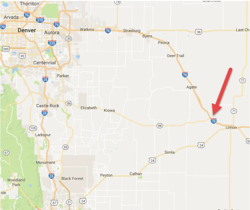
  • Freeway Shooting on I-70 Between Agate and Limon

    Freeway Shooting on I-70 Between Agate and Limon

    ELBERT COUNTY —  On 08/05/2017, at approximately 1247am Elbert County Sheriff’s Office Deputies responded to I-70 at mile marker 352 on a reported shooting. The victim, a man from Kansas was traveling eastbound on I-70 when a blue Honda 4-door pulled alongside of him and opened fire.

    Deputies arrived on scene and administered lifesaving medical treatment by applying a chest wound kit and tourniquet to stop the bleeding that resulted from several gunshot wounds. The victim who is in critical condition was transported to a local hospital helicopter.

    The motive for the shooting is unknown at this time. Investigators are currently conducting interviews in the area and reviewing video footage from businesses along the I-70 corridor.The victim described suspects to be driving blue Honda four door occupied by two males, the driver is described as white male, curly blond hair, black hoody and khaki shorts, the passenger described as white male white t-shirt and black pants. The suspects and vehicle have not been located at this time.

    Screen Shot 2016-08-05 at 11.37.20 AM

    If you have information that could be useful in the location of a witness or apprehension of a suspect please contact ECSO Investigations unit at 303-805-6109.

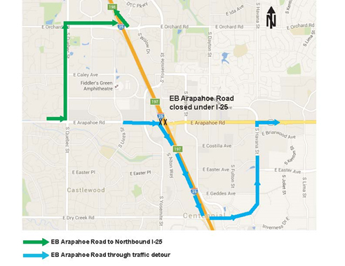
  • Eastbound Arapahoe Road Closed at I-25 Tonight 

    Eastbound Arapahoe Road Closed at I-25 Tonight 

    Greenwood Village — The Colorado Department of Transportation (CDOT) is closing eastbound Arapahoe Road under Interstate 25 overnight tonight for bridge work. Lane restrictions begin at 7 p.m., with the full closure at 10 p.m.  All lanes will reopen by 5:30 a.m. Tuesday. Westbound Arapahoe Road will remain open.

    All work is weather permitting and subject to change.

    Traffic Detour

    Detour map


    The project team reminds motorists to allow extra time for your commute, adhere to speed reductions on I-25 and Arapahoe Road and avoid distractions. Alternate routes are advised. Watch for weekly construction update emails with the most up-to-date information regarding traffic impacts.

    Project Information: This $66 million Responsible Acceleration of Maintenance (RAMP) Project includes building an additional lane along westbound Arapahoe Road from Yosemite Street to Greenwood Plaza Boulevard, providing three left turn lanes from the I-25 off-ramps, realigning the frontage road in the northeast quadrant of the interchange, building noise walls near the Arapahoe Road and Yosemite Street intersection and widening Yosemite Street from Yosemite Circle on the north to Xanthia Street on the south. This project is designed to reduce congestion and improve traffic operations and safety. Substantial completion is slated for summer 2018.


    For More Information:

    Project website: www.codot.gov/projects/I25-Arapahoe

    Project hotline: (720) 580-2525

    Sign up for project updates by emailing: 

    To receive real-time updates about road conditions in your area, click here

    Updates are also available via Twitter @coloradodot and be sure to “Like” our Facebook page at www.facebook.com/coloradodot


    Due to ongoing construction activity in this area and nighttime travel impacts, alternative transportation modes are encouraged. For information on the Regional Transportation District’s Southeast Rail Line or local bus services, call 303-299-6000. For information on carpool and vanpool services, call 303-458-7665.

  • Front Range Action Day for Ozone

    Front Range Action Day for Ozone

    The Colorado Department of Public Health and Environment and the Regional Air Quality Council have issued an OZONE ACTION DAY ALERT at 4 p.m. on Thursday, July 28, 2016 for the Front Range Urban Corridor from El Paso County north to Larimer and Weld counties, including the Denver-Boulder area, Colorado Springs, Fort Collins and Greeley.

    Increased levels of ozone may occur in the foothills south and west of the Denver metro area due ozone transport from areas outside of the Denver/North Front Range.This Ozone Action Day Alert will remain in effect until at least 4 p.m. Friday, July 29, 2016.

    The highest Ozone related AQI at 1 o’clock PM Mountain Standard Time on July 28, 2016, is 49 which indicates Good ozone air quality. It was recorded by the AURE ambient ozone monitor

    FRONT RANGE AIR QUALITY FORECAST:
    Thursday, July 28, 2016, 2:30 PM MDT

    Ozone concentrations are expected to be in the Moderate to possibly Unhealthy for Sensitive Groups rangeon Thursday and Friday. Ozone concentrations in the Unhealthy for Sensitive Groups category may occur in the south and west suburbs of Denver, including the nearby foothills. Active children and adults, and people with lung disease, such as asthma, should reduce prolonged or heavy outdoor exertion in those areas from noon until midnight on Thursday and Friday.

    Fine Particulate Matter concentrations are expected to be in the Good to Moderate range on Thursday andFriday. Unusually sensitive people should consider reducing prolonged or heavy exertion on Thursday andFriday.

    Carbon Monoxide concentrations are expected to be in the Good category on Thursday and Friday.

    Nitrogen Dioxide concentrations are expected to be in the Good category on Thursday and Friday.

    Visibility is expected to be Poor on Friday.

    SMOKE FROM OTHER WILDFIRES:
    The 27,893 acre Beaver Creek Wildfire is located in northwestern Jackson County approximately 24 miles northwest of Walden. Increasing west to northwesterly winds are expected at the fire on Thursday which would tend to send smoke to locations east and southeast of the fire. Depending on fire behavior, smoke could impact areas far downwind today including Rocky Mountain National Park and parts of the Front Range region. Light winds are expected at the fire late Thursday night and drainage flow will likely pool smoke, perhaps heavy at times, to northern parts of North Park into Friday morning. This would mainly include the area to the north of the community of Cowdrey to the Wyoming state line.

    Areas of haze and smoke are possible across the Front Range region on Thursday. This is due to northwesterly winds aloft transporting in smoke from the Beaver Creek fire and other wildfires burning in Wyoming.

  • Public meeting for Dry Creek Road/ I-25 Interchange & Corridor Study July 28

    Public meeting for Dry Creek Road/ I-25 Interchange & Corridor Study July 28

    Review and provide feedback regarding draft study recommendations

    LITTLETON — Arapahoe County with its partners of the City of Centennial and Southeast Public Improvement District are hosting a public open house for citizens to view alternative screening results and provide feedback regarding the draft study recommendations for the Dry Creek Road and I-25 Interchange and Corridor.

    The goals of the study are to develop a range of improvements to improve regional access, improve mobility and system reliability, improve congestion and safety, maximize existing infrastructure and consider all modes of transportation.

    The public open house is scheduled 4:30 – 6:30 p.m., July 28 at Good Shepherd Episcopal Church, 8545 E. Dry Creek Road, Centennial, 80112. Interested parties can view displays, learn more and get questions answered by project representatives.

    Graphic displays from the meeting will also be displayed on the project website beginning July 28 for submitting online comments. After input is gathered, study recommendations will be refined and prioritized.

    Visit the project website www.arapahoegov.com/DryCreekStudy for more information.